Berkeley Park Blueprints Plan (2004)
|
Introduction
|
The Berkeley Park plan was drafted in 2004 through the Georgia Conservancy’s ‘Blueprints for Successful Communities’ program. Neighborhood residents sought to establish a vision for Berkeley Park in order to guarantee that future development would lead to sustainable investment and growth in the area.
|
|
Community Workshops
|
The first engagement outcome was outlining the neighborhoods assets and challenges. Among the assets were neighborhood proximity to downtown and I-75, its density and resident diversity, historic character and architecture, and the potential for redevelopment along Howell Mill and Northside Drive. The challenges section was much longer and spoke to the state of disrepair of certain properties, the high speed and quantity of traffic, a lack of cohesive image, troubles maintaining new development size and scale consistent with neighborhood character, poor quality of walkable environment, and ineffective community-wide outreach.
Residents and Conservancy staff outlined a series of goals for Berkeley Park:
Design workshops were led to identify potential alternative solutions to the aforementioned challenges. Residents did not want covenants in place but rather wanted to draft an architectural style guide and enforce consistent setbacks. There was mention of drafting floor area ratio (FAR) restrictions for new construction. |
|
Existing Conditions
|
The predominant style in Berkeley Park is the bungalow, single-story, single-family home; median year built is 1943. Lot sizes are on average 50’ by 140’ with an average of 20’ setbacks. In 2004, 63.4% of homes were renter occupied. 2000 Census data indicated that the residents were primarily white (85.8%) and mostly male (60.2%).
Several corridors are identified and described. However, the section pertaining to this report is the northern portion of the Howell Mill corridor. It is described as having shallow lots with “single-story light industrial, commercial, and residential buildings”. Businesses along this corridor cater to the automobile (mechanics and drive through restaurants) rather than the pedestrian. The report also considers the overall redevelopment potential of the neighborhood and the existing transportation network. Howell Mill Road allows traffic to flow at a maximum speed of 35 miles per hour; the road varies in width from six lanes to four lanes within the area of study. The pedestrian environment along Howell Mill is described as often obstructed by trucks and hampered by driveways. |
|
Strategies and Recommenda-tions
|
The workshops led to a series of strategies for improving the transportation system in the neighborhood.
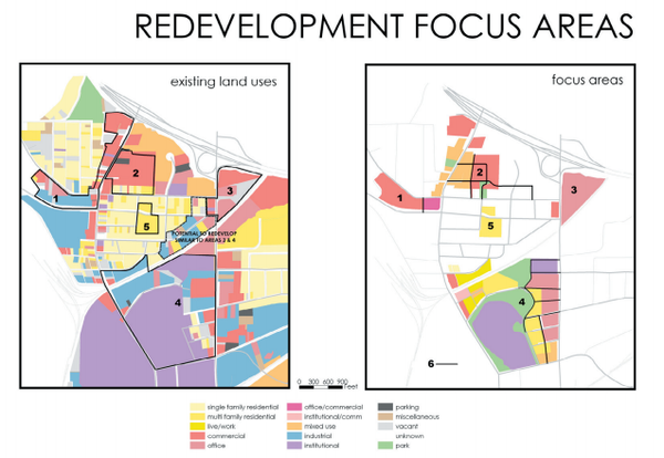
Figure 1: Redevelopment Focus Areas
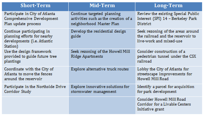
Figure 2: Proposed strategic Actions
|
